ST. GEORGE — Nowadays Valentine’s Day expectations are so high, even if you transformed overnight into a hybrid of Ryan Gosling and Prince Harry or Betty Crocker in Megan Fox’s body, your partner would still be let down. So, rather then boycott Valentine’s Day all together, make it simple, take a hike.

Use these tips to truly make your lover feel special this Valentine’s Day, then choose from one of these simple nearby romantic getaway hikes.
Romantic hiking tips
All your partner really wants is acknowledgment that they are important in your life. The forethought involved with making a plan is just as important as the plan. Take half an hour, make a plan and use the following ideas to get it started.
• A cuddle sesh at a breathtaking overlook exemplifies romance. Around here, it’s not difficult to make that scene a reality – see the suggestions below. Bring a sleeping pad on the hike, and a really comfy blanket, or better yet, a couple’s sleeping bag for a backcountry snuggle.
• Make your Facebook-stalking in-laws proud, and your partner delighted, by documenting the hike with photos and broadcasting your romantic side to your social network. Take plenty of photos and take the time to post them on your sweetie’s wall – laid out in a cute way, or even better, print them and make a collage.
• Your lover wants to know that her desires are important to you, so this hike would be a great time to let go of your need to control, and let her control the hike’s pace. Express to her from the get go that she is in charge.
• Gift giving is deeply engrained in our Valentine’s day culture, use this opportunity to buy your partner his own headlamp, or daypack, or water bottle, and weave this into your V-day gifts.
• Nothing feels better than a well thought out surprise. Shake it up and bring a unique snack: Resist the chocolate dipped strawberries routine, it’s overused. Instead, bring some high-end cheeses with organic crackers, exotic fruits, or even homemade hummus – super easy to make, guys.
• A polite gesture goes a long way these days. Hold your hand out, and assist your partner over obstacles. And, for goodness sake, hold those pokey branches back for him when you cross the path of a reachy tree or bush. NOTE: Do not attempt this if your sweetheart is one of those independent types. Use your own discretion, people.
• There’s nothing more comforting then a warm drink, especially in the winter. Comfort your sweetie by bringing a thermos (ideally one of those modern, high-quality insulated containers) full of hot tea or hot chocolate, or even better, caramel apple cider.

Top three romantic St. George hikes
Being in nature is innately romantic. All three of these nearby hikes will give you lovebirds a midway spot perfect for a cuddle session or picnic. If you’ve been together for a really long time, these offer nice open spaces for you to wander away from each other.
1. West-facing sunset panorama, with hike back lit by the full moon
A 4.5-mile up-and-back hike in the Santa Clara River Reserve sets up a circumstance so romantic that Aphrodite herself must have designed it. Considering the Feb. 14 full moon this year, the environmental conditions for this hike are impeccable. This is the ideal local spot for a romantic sunset viewing followed by a full moon-lit hike back to the car. These are the fairytale circumstances when nature babies are made.
Hike 2.25 miles up a massive tilted plateau to the impeccably placed slab (pictured) that acts as your sunset viewpoint. This slab is nothing more than a naturally occurring back patio, decorated with a few mini trees and natural furniture – a coffee table rock and some seat-shaped boulders. This slab is attached to the top of a ridge which overlooks the remote basin and range region. Here you will find a view so vast you can almost see the curvature of the earth.
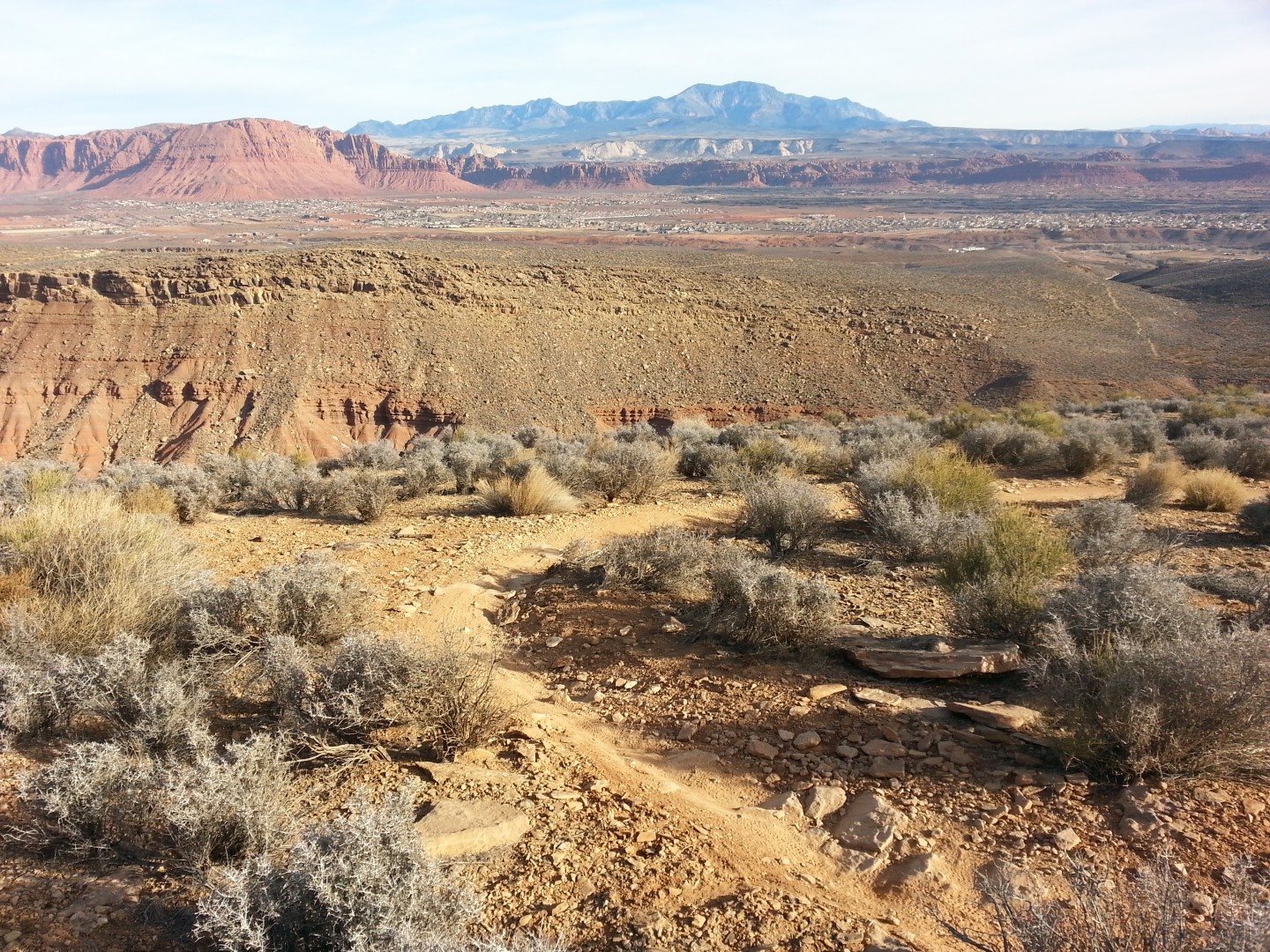
TIP: The sunset is slated for 6:13 p.m. Friday according to the U.S. Naval Observatory. Although the moon should light the way, don’t forget to bring headlamps in case you get lost, or those winter clouds block the moonrise. It’s still another 2.25 miles back to the car. Also, because there is no sand or grass, a few camping chairs would be ideal if you prefer more than rock chairs.
HIKING DIRECTIONS: From the Cove Wash Trailhead (see below), follow the well-marked Barrel Roll Trail, then branch off at the well-marked Sidewinder Trail which will take you to the viewpoint. A total distance of 2.25 miles gets you to the viewpoint.
The trail is well-worn, and mildly uneven, although the entire hike to the viewpoint is mostly a gradual incline. The good news is, when you turn around and retrace your steps back to the car, it’s mostly all downhill.
NOTE: Shortly after the Barrel Roll Trail begins, a left branch will put you on the Sidewinder Trail. Do not take this fork. Continue straight west on the Barrel Roll trail.
TRAILHEAD: From the Sunset Boulevard-Bluff Street intersection drive west on Sunset for 3.6 miles. Turn left on Gates Lane in Santa Clara. In .3 miles turn right on to Clary Hills Lane and take an immediate left onto an unmaintained dirt road – more like an ATV road. Drive .3 miles to the Cove Wash Trailhead sign. Take a hard right at this sign and follow the path that takes you to the water tower west of you atop a hill. Pass the water tower and follow another Cove Wash Trailhead sign a short distance to the well-marked trailhead.

Once off the pavement, there is a total of 1 mile of driving on the ATV trail.
NOTE: To get to this trailhead, a high-clearance vehicle is recommended. However, for the experienced off-road traveler, a passenger car can make it to the trailhead, but be warned, your undercarriage may get scraped up a bit.
2. Short hike to classic picnic spot
A short distance from the Chuckwalla Trailhead is the best wilderness picnic spot around St. George. This 3/4 mile hike takes you to a naturally occurring grassy meadow, perfectly placed under a few giant cottonwood trees, and next to a stream. In the winter, the lifeless grassy patch is blanketed with fallen leaves perfect for a Valentine’s roll-about.
Set up your picnic under one of the trees, and enjoy the views of the Green Valley area of St. George, along with the Black Ridge to the south, and walk down to the creek where another grove of cottonwoods stands a few hundred feet to the west. Then when you’re nice and sick of each other again, trace your steps back to the trailhead.
HIKING DIRECTIONS: From the parking lot of the Chuckwalla Trailhead (see below), follow the Chuckwalla Trail signs north for 3/4 of a mile. The descending trail takes one major S-curve and shortly thereafter starts trending north again. Thick bushes enclose the trail shortly before two giant unmistakable Cottonwood trees, which mark the natural picnic spot.
TRAILHEAD: Park at the well-marked Chuckwalla Trailhead just off North Bluff street, exactly 1 mile north of the Sunset Boulevard-Bluff Street intersection.

3. Take-your-breath-away viewpoint, picturesque romantic cuddle spot
Halfway through this 4.8 mile up-and-back, you’ll find a viewpoint so powerful that if you weren’t in love with your Valentine’s Day hiking companion before, mother nature just changed that.
This glorious viewpoint of Snow Canyon State Park comes with a huge flat slab of sandstone to set up your pad and blanket, plus close by there are wide open sandy areas to roll around in.
Tromp through a thick high-desert pinion and juniper forest, stomp up the steadily inclining Red Mountain Trail, and veer off for a startling grand finale — an out-of-this-world birdseye view down the massive sandstone cavity that is Snow Canyon State Park in this 4.8 mile up-and-back hike.
HIKING DIRECTIONS: For the first 1.2 miles, the Red Mountain Trail persistently gains elevation — 300 feet of elevation to be exact. At the 1/2 mile mark, hop over the step-over gate and you’ll enter the remote Red Mountain Wilderness. At 1.2 miles, the trail stops its persistent climb and roller coasters for .4 miles before sharply dropping in elevation. Veer off to the left at a miniature entryway marked by two cairns (stacks of rocks signifying an informal trail) about 5 feet apart from each other.

NOTE: If you somehow miss this particular turn, you can turn left a short distance before the double cairn, or a short distance after it to reach either of the other respective viewpoints both of which don’t add much distance to the overall hike length.
Follow this branch of the trail, marked by the double cairns, for 1/4 mile down a sandy slope and quickly back up the other side. Abruptly you will reach what seems like the end of the earth and the breathtaking view off the Snow Canyon Overlook.
After communing with your lover in nature, turn around and head straight back from whence you came.
TRAILHEAD: Start at the Red Mountain Trailhead, .4 miles past mile marker 15 on Highway 18. The trailhead is between the small towns of Diamond Valley and Dammeron Valley, 12 miles north of St. George.
NOTE: The Snow Canyon Overlook can be accessed from a variety of different ways, but this route seems to have the most bang for your buck.
Click here for a more in-depth trail review of the Snow Canyon Overlook.
Related Posts
- Trail Review: Hike the Red Mountain Trail this holiday for jaw-dropping Snow Canyon panorama
- Trail Review: A secret Snow Canyon gem, get the views without the fee
- Trail Review: Take a turkey day trot on Owens Loop, easy to access, family friendly
- Parks are Open; Take advantage while you can with this one-day Zion-Bryce tour guide
- Shutdown: Snow Canyon State Park sees revenue surge during national parks closure
Email: [email protected]
Twitter: @STGnews
Copyright St. George News, SaintGeorgeUtah.com LLC, 2014, all rights reserved.

Drew, which of these hikes do you recommend I send my wife on? I don’t want to worry about her while I am home watching TV, so nothing dangerous please.
Also, she needs to be home before dark to do some yard work, so nothing too long.