SOUTHERN UTAH — The National Weather Service has issued a “Flash Flood Watch” for Washington, Iron, and Kane counties, in effect Monday from noon to 9 p.m. and from 9 a.m. to 9 p.m. for Mesquite, Nevada.
Conditions
Numerous slow-moving showers and thunderstorms will track north across southern and central Utah Monday. Some of these showers and thunderstorms will generate very heavy rain in short periods of time. Flash flooding will be possible in the more flash flood prone areas beginning Monday afternoon.
Potential for flash flooding across the southern Great Basin and Mojave Desert: Several upper level disturbances could potentially organize strong thunderstorms Monday throughout Monday evening. Plenty of moisture is in place across the southern Great Basin and Mojave Desert with flash flooding the primary concern.
Affected areas
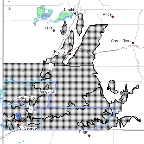
Portions of central, southern and southwest Utah, including the cities of Beaver, Cedar City, Milford, St. George, Kanab, Escalante, Bullfrog, Cove Fort, Koosharem, Fish Lake, Loa, Panguitch, Bryce Canyon, and the following areas:
- Central Utah: Central Mountains
- Southern Utah: Glen Canyon Recreation Area/Lake Powell, south central Utah, southwest Utah, Utah’s Dixie, Zion National Park, and the southern mountains
Portions of northwest Arizona, California and Nevada, including the following areas:
- Northwest Arizona: Lake Havasu and Fort Mohave, Lake Mead National Recreation Area, northwest Deserts and northwest Plateau
-
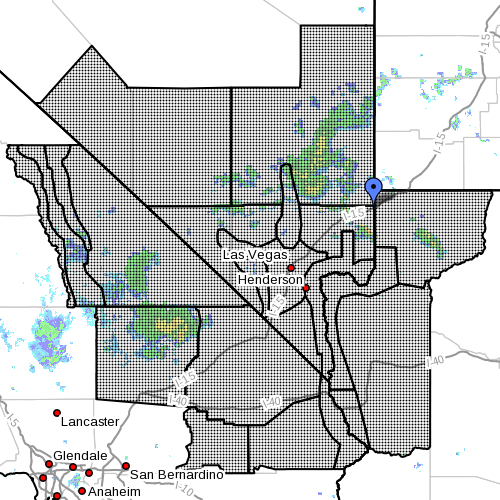
Dots denote affected area at radar time 11 a.m., Arizona, California and Nevada, July 28, 2014 | Image courtesy of the National Weather Service California: Cadiz Basin, Death Valley National Park, eastern Mojave Desert, eastern Sierra Slopes, Morongo Basin, Owens Valley, San Bernardino County, upper Colorado River Valley, western Mojave Desert and White Mountains of Inyo County
- Nevada: Esmeralda and Central Nye County, Lake Mead National Recreation Area, Las Vegas Valley, Lincoln County, northeast Clark County, Sheep Range, southern Clark County, Spring Mountains, Red Rock Canyon, western Clark County and southern Nye County
Most threatened
The flash flood threat will be greatest in the slot canyons and slick rock areas of extreme Southern Utah during the afternoon. The threat will shift north into central Utah during the late afternoon and evening.
Thunderstorms could easily produce one to two inches of rainfall in a short period of time. Areas of steep terrain or old burn scars will be the most prone to flash flooding and are also more susceptible to increased runoff or debris flows.
Precautionary, preparedness actions
A flash flood watch means that conditions may develop that lead to flash flooding. Flash flooding is a very dangerous situation. You should monitor later forecasts and be prepared to take action should flash flood warnings be issued.
Turn around. Don’t drown.
The National Oceanic and Atmospheric Association and the National Weather Service offer safety rules for flash flooding:
- Flash flooding is a very dangerous situation
- Flash flood waves, moving at incredible speeds, can roll boulders, tear out trees, destroy buildings and bridges, and scour out new channels. Killing walls of water can reach heights of 10 to 20 feet. You will not always have warning that these deadly, sudden floods are coming. When a flash flood warning is issued for your area or the moment you first realize that a flash flood is imminent, act quickly to save yourself. You may have only seconds.
- Most flood deaths occur in automobiles. Do not drive your vehicle into areas where the water covers the roadway. Flood waters are usually deeper than they appear. The road bed may not be intact under the water. Just one foot of flowing water is powerful enough to sweep vehicles off the road. If the vehicle stalls, abandon it immediately and seek higher ground. Rapidly rising water may engulf the vehicle and its occupants and sweep them away
- Do not hike rivers and especially slot canyons while flash flood warnings are in place
- Do not hike alone and always tell someone where you and your buddy and others are going
- Get out of areas subject to flooding, including dips, low spots, canyons, and washes
- Avoid already flooded and high velocity flow areas. Do not try to cross a flowing stream on foot where water is above your knees
- Be especially cautious at night when it is harder to recognize flood dangers
- Do not camp or park your vehicle along streams and washes, particularly during threatening conditions
- During any flood emergency, stay tuned to your NOAA weather radio, commercial radio, or television, follow St. George News at STGnews.com and St. George News Facebook for weather alerts and updates relevant to Southern Utah. Information from the national weather service and disaster and emergency services may save your life
Related posts
- What to do before, during, after a flash flood
- I can’t believe I survived; video of flash flood crashing down on canyoneers
- Flash Flooding in Washington City
- Highway through Zion Park closed due to flooding
- Angell Heights Estates in Hurricane threatened by heavy rainfall, flooding; STGnews Photo Gallery
- Thunderstorms trigger flooding near Panguitch
- Flash flooding Washington County; STGnews Photo Gallery
- Record rainfall in Cedar City results in ‘massive flooding’ throughout city; STGnews Photo Gallery
- Flash Flood Watch for Southern Utah; STGnews Videocast of Washington City urban flooding
- Flash flooding meets River Road near Southern Parkway; Videocast, STGnews photo gallery
Email: [email protected]
Twitter: @STGnews
Copyright St. George News, SaintGeorgeUtah.com LLC, 2014, all rights reserved.