SOUTHERN UTAH – Multiple warnings and updates have been issued for Southern and central Utah, including a heavy snow warning, an avalanche warning for the southern mountains, road closures and alerts to poor driving conditions on many of the area’s roads and highways.

Heavy snow warning
The National Weather Service has issued an urgent updated winter storm warning for heavy snow.
Affected area
South central Utah
Snow accumulations and levels
Storm total snow of 8-14 inches above 5,500 feet with 1-4 inches elsewhere are forecast. Locally higher amounts are possible near Orderville and along Highway 12. Snow levels are fluctuating between 5,000 feet and 5,500 feet.
Timing
Snow mixing with rain at times below 5,500 feet will continue, heavy at times, into the afternoon before slowly tapering off.
Impacts
Winter driving conditions including snow packed roads and significantly reduced visibility can be expected along Highway 89 north of Kanab, as well as along Highway 12 and other area highways. Travel may be difficult at times due to the heavy snow.
Road conditions – emergency alert
The Utah Department of Transportation has issued emergency alerts for Iron, Kane and Garfield counties.
State Route 14 is closed due to hazardous weather conditions. State Route 20 and state Route 143 travel requires chains or four-wheel drive.
Road conditions – additional travel alerts
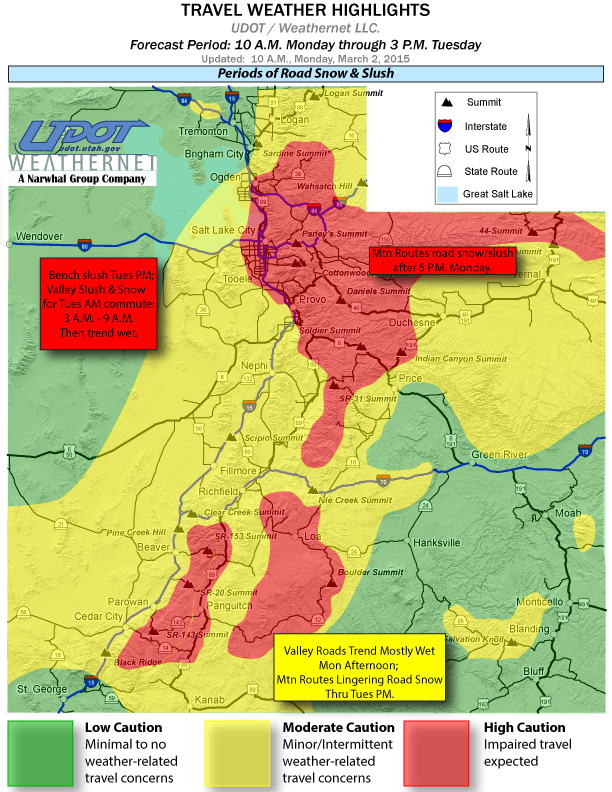
UDOT has also issued weather alerts for road snow and slush conditions continuing through 9 a.m. Tuesday.
Interstate 15
- Periods of road slush and road snow will impact Interstate 15 between Nephi and Black Ridge through Monday.
- Road snow is heavy in some areas Monday morning, especially between Cedar City and Cove Fort (I-15 junction). Periodic snow may continue through Tuesday.
Interstate 70
- Road slush and snow will continue to impact I-70 over Clear Creek Summit (between Interstate 15 and Sevier) through the forecast period. Roads may turn mostly wet Monday afternoon, except for under a heavier snow shower. Road snow is expected to become heavy at times through Monday morning. Periodic snow may continue through Tuesday.
- Interstate 70 between Sevier and Salina will experience road snow and slush through the forecast period. Roads may turn mostly wet Monday afternoon, under any light showers. Periodic snow may continue through Tuesday.
- Road snow and slush will impact travel along I-70 over Ivie Creek Summit (between Salina and Fremont Junction) through the forecast period. Road snow is expected to become heavy at times. Roads may turn mostly wet Monday afternoon, except for under a heavier snow shower. Periodic snow may continue through Tuesday.
- I-70 between Fremont Junction and Green River will experience light road snow and slush through late Monday morning. Roads turn mostly wet Monday afternoon, under any light showers. Patchy ice may linger Monday night into Tuesday morning.
Highway 6
- Light road snow and slush will impact travel on Highway 6 between Nevada and Eureka through late Monday morning. Otherwise, roads will run mostly wet under any showers Monday afternoon. Patchy ice and light road slush may linger through Monday night into Tuesday morning.
- Road snow and slush, which may be heavy at times, will impact Highway 6 over Soldier Summit (between Thistle and Helper) through the forecast period.
Highway 50
- Light road snow and slush will impact travel on Highway 50 between Delta and Salina through late Monday morning. Otherwise, roads will run mostly wet under any showers Monday afternoon. Patchy ice and light road slush may linger through Monday night into Tuesday morning.
- Highway 89
Road slush and light road snow will impact Highway 89 between Thistle and I-70 through Monday morning. Roads turn mostly wet Monday afternoon, under any light showers. Patchy ice and light road slush may linger through Monday night into Tuesday morning. - Road slush and snow will continue to impact Highway 89 between I-70 and Circleville through Monday morning. Roads may turn mostly wet Sunday afternoon, except for under heavier snowfall. Road snow is expected to become heavy at times through early Monday morning. Periodic snow may continue through Tuesday.
- Periods of road slush and snow, heavy at times, will continue to impact Highway 89 between Circleville and Glendale through Monday morning. Patchy snow and ice will linger through Monday night. Periodic snow may continue through Tuesday. Please travel with caution.
- Highway 89 from Glendale through Kanab will continue to experience periods of road slush and snow through the forecast period. Roads may turn mostly wet Monday afternoon, except for under heavier snowfall. Road snow may become heavy at times through early Monday morning, especially near Glendale. Periodic snow may continue through Tuesday.
Highway 191
- Road snow, heavy at times, will impact Highway 191 over Indian Canyon Summit (between Duchesne and Helper) through the forecast period.
- Periods of light road snow and slush, along with pockets of blowing snow, will impact Highway 191 between La Sal Junction and Blanding through Monday afternoon. Patchy ice may linger Monday night into Tuesday morning.
Other central/southern valley routes
- Periods of road snow and slush will continue to impact State Route 130 over Minersville Pass (between Cedar City and Minersville), State Route 21 (west of Beaver), and State Route 56 (between the Nevada border and Cedar City) through the forecast period. Road snow is expected to become heavy in some areas into Monday morning. Please travel with caution.
- State Route 95 between Lake Powell and Blanding (over Salvation Knoll) will experience periods of road slush and ice, along with pockets of blowing snow through Monday afternoon. Roads may trend wet Monday afternoon, except for under heavier snowfall. Patchy ice may linger Monday night into Tuesday morning.
- Periods of light road slush and snow will impact State Route 28 (between Nephi and Gunnison) through the forecast period. Roads will trend wet Monday afternoon. Periodic snow may continue through Tuesday.
State Route 46 (between Highway 191 and the Colorado border), and Highway 491 (between Monticello and the Colorado border), will continue to experience periods of road slush and ice, along with pockets of blowing snow, through Monday morning. Roads may trend wet Monday afternoon, except for under heavier snowfall. Patchy ice may linger Monday night into Tuesday morning.
Other central/southern mountain routes
- Road snow, heavy at times, will continue to impair travel along State Route 153 (east of Beaver), State Route 143 over Brian Head (between Parowan and Panguitch), State Route 20 top of Bear Valley (between Highway 89 and Interstate 15), and State Route 14 (east of Cedar City) through the forecast period. Snow is expected to continue into Monday night and possibly Tuesday. Motorists should travel with extreme caution.
- Periods of road slush and snow, heavy at times over higher elevations, will continue to impact travel along State Route 12 over Boulder Summit and through Bryce Canyon (between Panguitch and Torrey), State Route 62 (between Kingston and State Route 24), State Route 24 over Wayne Summit (between Richfield and Torrey), and State Route 72 (through Hogan Pass) through the forecast period. Snow is expected to continue into Monday night and possibly Tuesday. Motorists should travel with extreme caution.
- State Route 31 (between Fairview and Huntington), and State Route 264/ State Route 96 (between Highway 6 and State Route 31), will continue to see periods of road snow through the forecast period. Snow is expected to continue into Monday night and possibly Tuesday.
Avalanche warning
The U.S. Forest Service Utah Avalanche Center has issued an avalanche warning for the mountains of southwest Utah.
Heavy snow is causing a high avalanche danger, which should continue through Tuesday. Backcountry travelers should avoid slopes steeper than 30 degrees, and stay out from underneath steep slopes.
This warning does not include ski areas or highways where avalanche control is normally done.
For more information visit Avalanche.org or call 1-888-999-4019.
Precautionary preparedness
A winter storm warning for heavy snow means that significant accumulations of snow are expected or occurring. Driving conditions may be hazardous . Use caution, and keep a winter storm survival kit in your vehicle in case of an emergency.
Resources
- Utah Department of Transportation Road Weather Alert webpage.
- For more information visit the National Weather Service website
- Utah Department of Transportation website.
- For Arizona road conditions, visit the ADOT Traveler Information Center at AZ511.gov or call 511; outside of Arizona dial 1-888-411-7623.
Related posts
- Police Department offers winter weather driving tips
- Schnapps anyone? Red Cross busts winter-safety myths
- Stocking your vehicle for winter; what to do in case of emergency, checklist
Email: [email protected]
Twitter: @STGnews
Copyright St. George News, SaintGeorgeUtah.com LLC, 2015, all rights reserved.
should of took a cab when it snows