SOUTHERN UTAH – The National Weather Service has issued a “Flash Flood Watch” for Washington, Iron, Beaver, Kane and Garfield counties in effect from midnight Tuesday through Wednesday evening.
Affected areas
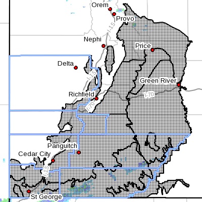
Portions of central Utah and Southern Utah, including the following areas: San Rafael Swell, Castle Country, central and southern mountains, Wasatch Plateau, Glen Canyon Recreation Area/Lake Powell, south central Utah and Zion National Park, including the cities of Scofield, Price, Castle Dale, Emery, Green River, Hanksville, St. George, Kanab, Escalante, Bullfrog, Cove Fort, Koosharem, Fish Lake, Loa, Panguitch and Bryce Canyon.
Impacts
Tropical moisture spreading northward will bring an increasing threat for showers and thunderstorms capable of producing heavy rainfall tonight into the day Wednesday. These storms will be most numerous Wednesday afternoon and evening.
The flash flood threat will be greatest across slot canyons, slick rock areas, normally dry washes and small streams in steep terrain. Travel may become difficult or impossible on both backcountry and maintained roadways overnight through Wednesday evening.
Precautionary, preparedness actions
A flash flood watch means that conditions may develop that lead to flash flooding. Flash flooding is a very dangerous situation.
Anyone traveling near these areas through the nighttime hours is cautioned to use prudent judgment to ensure safety.
Turn around. Don’t drown.
Read more: Rescue commander tells how to survive a flash flood
The National Oceanic and Atmospheric Association and the National Weather Service offer safety rules for flash flooding:
- Flash flooding is a very dangerous situation
- Flash flood waves, moving at incredible speeds, can roll boulders, tear out trees, destroy buildings and bridges and scour out new channels. Killing walls of water can reach heights of 10 to 20 feet. You will not always have warning that these deadly, sudden floods are coming. When a flash flood warning is issued for your area or the moment you first realize that a flash flood is imminent, act quickly to save yourself. You may have only seconds.
- Most flood deaths occur in automobiles. Do not drive your vehicle into areas where the water covers the roadway. Flood waters are usually deeper than they appear. The road bed may not be intact under the water. Just one foot of flowing water is powerful enough to sweep vehicles off the road. If the vehicle stalls, abandon it immediately and seek higher ground. Rapidly rising water may engulf the vehicle and its occupants and sweep them away
- Do not hike rivers and especially slot canyons while flash flood warnings are in place
- Do not hike alone and always tell someone where you and your buddy and others are going
- Get out of areas subject to flooding, including dips, low spots, canyons and washes
- Avoid already flooded and high velocity flow areas. Do not try to cross a flowing stream on foot where water is above your knees
- Be especially cautious at night when it is harder to recognize flood dangers
- Do not camp or park your vehicle along streams and washes, particularly during threatening conditions
During any flood emergency, stay tuned to your NOAA weather radio, commercial radio or television, follow St. George News at STGnews.com and St. George News Facebook for weather alerts and updates relevant to Southern Utah. Information from the National Weather Service and disaster and emergency services may save your life.
Related posts
- What to do before, during, after a flash flood
- I can’t believe I survived; video of flash flood crashing down on canyoneers
- News LIVE: Heavy rains shut down Virgin River Gorge
- St. George Library floods for 3rd time after heavy rains
- News LIVE: Heavy rains cause flooding, structure failures, multiple car accidents; UPDATED 11 PM, STGnews Photo Gallery
- Washington City hosts ‘Help our Community’ flood-relief event
- Rainy day rescue: Fundraising website set up for Washington flood victims
- Storm swells Virgin River, flash flood at Fort Pierce Bridge; STGnews Aerial Videocast
- News LIVE: Storm hits Washington, homes flooded; STGnews Photo Gallery
Email: [email protected]
Twitter: @STGnews
Copyright St. George News, SaintGeorgeUtah.com LLC, 2015, all rights reserved.