FREDONIA, Ariz. — Crews continued burning on the west end of Burnt Corral Ridge Tuesday, assessing the need to continue burnout operations as necessary to reinforce the wildfire’s established perimeter boundary and monitoring fire behavior and weather.
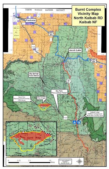
The lightning-caused Burnt Complex Fire is made up of the Burnt and Corral fires, discovered on July 5 and 9, respectively. It is currently 2,483 acres and is fueled by pine, down woody debris, duff and litter (material on the forest floor consisting of decomposing needles and other natural materials).
The crew, currently working under the command of a Type 4 incident commander, consists of nineteen local wildland firefighters, with 25 personnel total, two Type 6 engines and one Type 2 Saguaro Wildland Fire Module from Saguaro National Park, Tucson, Arizona.
Wednesday, fire managers will continue to execute the established management strategy to allow the wildfire to slowly work its way across the forest floor to reduce fuel loads inside the approved 3,915-acrea planning area, bound by Forest Service Road 228 on the north, FSR 274 on the south and west and FSR 22 on the east.
“The key here is patience,” North Kaibab District Ranger Randall Walker said. “The fire has to be allowed to play its role on the landscape naturally so it achieves the desired effects we want. Our burning operations are just one tool we use to help manipulate and maintain the low-intensity fire behavior that we want so we can improve our collective effectiveness at reducing high-severity wildfire impacts in the future.”
Smoke is visible but minimal throughout portions of the district.
There are currently no road or trail closures are in effect or anticipated. However, hazard signs are posted, and motorists should exercise caution when around traveling near the planning area boundary.
Related posts
- Additional assets arrive to support 1,387-acre Springs Fire
- High Meadow Fire continues burning, 640 acres in size
- Springs Fire grows despite recent rain, plays role in ecosystem
Email: [email protected]
Twitter: @STGnews