ST. GEORGE — Thunderstorms are producing heavy rainfall and some hail in the region and flash flooding is expected to begin shortly for sections of Washington and Iron counties.
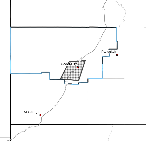
The National Weather Service in Salt Lake City has issued a flash flood warning for east-central Washington County and west-central Kane County. This warning is in effect until 10:45 p.m. MDT.
At approximately 6:43 p.m. Doppler radar indicated a thunderstorm producing heavy rain over Zion National Park, including the east and north forks of the Virgin River, including The Narrows.
Some locations that will likely experience flooding includes Zion National Park, Springdale and Rockville.
Precautionary – preparedness actions
Flooding is occurring or is imminent. It is important to know where you are relative to streams, rivers or creeks which can become killers in heavy rains.
Campers and hikers should avoid streams or creeks.
Please report flooding to your local law enforcement agency when you can do so safely.
Area flood watch
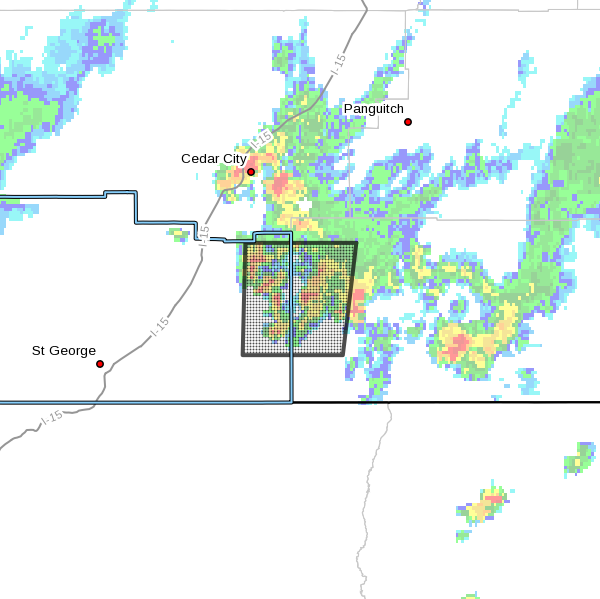
In addition to the flash flood warning, the National Weather Service has also issued a flood warning for south-central Iron County. This watch is in effect until 8 p.m. MDT.
At 6:59 p.m. Doppler radar indicated heavy rain due to thunderstorms. This will cause minor flooding in the Cedar City area.
Some locations that will likely experience flooding includes Cedar City, Enoch, Kanarraville and Hamilton Fort.
Click on photo to enlarge it, then use your left-right arrow keys to cycle through the gallery.
Flash flood warning has been issued for the shaded area on the map, primarily in the vicinity of Zion National Park, Springdale and Rockville | Image courtesy of the National Weather Service, St. George News Shaded area on the map indicates location of area flood advisory issued by the National Weather Service | Image courtesy of National Weather Service, St. George News A thunderstorm moving through south-central Iron County has caused an area flood watch to be issued by the National Weather Service, Cedar City, Utah, Aug 1, 2016 | Photo by Iron County resident, St. George News A thunderstorm moving through south-central Iron County has caused an area flood watch to be issued by the National Weather Service, Cedar City, Utah, Aug 1, 2016 | Photo by Iron County resident, St. George News A thunderstorm moving through south-central Iron County has caused an area flood watch to be issued by the National Weather Service, Cedar City, Utah, Aug 1, 2016 | Photo by Iron County resident, St. George News")
")


Email: [email protected]
Twitter: @STGnews