ST. GEORGE – An incoming storm system with very heavy rainfall and localized flooding is forecast by the National Weather Service for specified areas of Utah, Nevada, Arizona and California beginning at 11 a.m. and noon, PDT/MDT respectively, Wednesday, with a possible brief lull Thursday before resuming until midnight.
Monsoonal moisture will continue to advance into the areas ahead of the storm system.
“Conditions will be favorable for thunderstorms with very heavy rainfall and localized flooding,” the weather service’s notice states.
Storms are expected to develop in Southern Utah and north-central Arizona Wednesday afternoon, moving southwest into portions of Nevada and Mohave County, Arizona, in the evening.
The storms are expected to develop in the higher terrain of the specified California, Nevada and Arizona areas by early afternoon Wednesday with very heavy downpours likely. The strongest storms may lead to localized flooding.
Affected areas
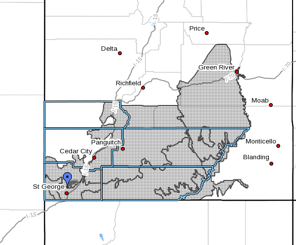
Parts of southern Nevada, southeastern California, northwestern Arizona, and central and Southern Utah. More particularly:
- In California: The northwest plateau and deserts in California.
- In Nevada: Lake Mead National Recreation Area, eastern Mojave Desert, Lincoln and northeast and southern Clark counties, Sheep Range, Spring Mountains, Red Rock Canyon and Las Vegas Valley.
- In Utah: San Rafael Swell, Glen Canyon Recreation Area, Lake Powell, southern mountains, Utah’s Dixie and Zion National Park; and areas in and around the following municipalities: Green River, Hanksville, St. George, Kanab, Escalante, Bullfrog, Loa, Panguitch and Bryce Canyon.

Flash flood watch – timing
Flash flood watches are in effect for all the specified areas through midnight Thursday.
Impacts
Flooding of urban areas with poor drainage is possible. Rapidly flowing water – along with mud and rocks – may affect area roadways and low-lying areas. Some roads may become impassable or damaged by flood waters.
Remember the maxim: Turn around, don’t drown.
Rapid rises in local washes and drainages are likely.
Areas at higher risk of flash flooding include slot canyons, slickrock areas, normally dry washes and small streams in steep terrain.
Prepare and take precautions
A flash flood watch means that conditions may develop that lead to the very dangerous condition of flash flooding.
A flash flood can happen with little or no warning, and individuals may only have seconds to act before it’s too late. Move to higher ground. Act quickly to protect your life, not your property.
“Get everybody. Don’t try to save personal belongings or vehicles,” Washington County Sheriff’s Deputy Darrell Cashin, then Search and Rescue Commander, said in a 2015 interview with St. George News, reflecting on a recent rescue.
After getting to higher ground, he said, it is important for people to remain where they are until either the waters have receded to a safe depth or rescue has arrived.
When you think it’s safe, wait, Cashin said.
“Let it recede, let it pass. When you think it’s safe, wait an hour longer.”
Read more: Rescue commander tells how to survive a flash flood
The National Oceanic and Atmospheric Association and the National Weather Service offer safety rules for flash flooding:
- Flash flooding is a very dangerous situation.
- Flash flood waves, moving at incredible speeds, can roll boulders, tear out trees, destroy buildings and bridges, and scour out new channels. Killing walls of water can reach heights of 10 to 20 feet. You will not always have warning that these deadly, sudden floods are coming. When a flash flood warning is issued for your area or the moment you first realize that a flash flood is imminent, act quickly to save yourself. You may have only seconds.
- Most flood deaths occur in automobiles – do not drive your vehicle into areas where the water covers the roadway; flood waters are usually deeper than they appear; the road bed may not be intact under the water
- Just one foot of flowing water is powerful enough to sweep vehicles off the road; if the vehicle stalls, abandon it immediately and seek higher ground; rapidly rising water may engulf the vehicle and its occupants and sweep them away.
- Do not hike rivers and especially slot canyons while flash flood warnings are in place.
- Do not hike alone and always tell someone where you and your buddy and others are going.
- Get out of areas subject to flooding, including dips, low spots, canyons and washes.
- Avoid already flooded and high velocity flow areas. Do not try to cross a flowing stream on foot where water is above your knees.
- Be especially cautious at night when it is harder to recognize flood dangers.
- Do not camp or park your vehicle along streams and washes, particularly during threatening conditions.
Email: [email protected]
Twitter: @STGnews
Copyright St. George News, SaintGeorgeUtah.com LLC, 2016, all rights reserved.
GO RAIDERS !!! GO LADYBUG !!! ♡♡♡
Yes! Go Raiders….my car is ready for some football. I’ve got my Raider steering wheel cover, my Raider headrest covers and my Raider air fresheners to hang on rear view mirror are on their way! Go Raiders!
Have a great day Dot ?
Go jump in a lake!!!
most of us share that sentiment, but replace LAKE with CLIFF
meh, y’all know what i meant
You first
GO RAIDERS !!!! GO LADYBUG !!! ♡♡♡♡♡
It ain’t gonna rain, and if it does it will only make your car’s windshield dirty. These rain criers give out all these warnings like candy at a parade. I hope it does rain, but I don’t think it will rain all that much. And I’m tired of my cartoons being interrupted with weather alerts. Tell ya what, if it rains hard enough to flood us, I’ll take you all out for sandwiches and beers.
?
My place didn’t flood but a tree almost uprooted completely it’s being held by a 2×4. Do I still get a beer?
Hmmm, no flood, but eh, lets have a beer anyways. It was close enough.
I’ll bring the chips and Salsa Real Life won’t show up because he doesn’t like me. ..but God bless him ..
Dear Editor, Are you LEGALLY required to ‘print’ EVERY post? Just wondering…
Fair question, DB. No, I am not and I do not; I am assuming you mean comments to the stories. 😀
ST. GEORGE NEWS
Joyce Kuzmanic
Editor in Chief
That’s exactly what I meant, Thanks…
P.S. Funny how ‘dot’ assumed I was talking about him 🙂
Funny how DB assumed I assumed what DB assumed wasn’t it ? …have a nice day
Dear Editor Are you LEGALLY required to ‘ print ‘ every post DB puts up ? LOL ! ……Hey what’s fair for the Goose is fair for the Gander. …..have a nice day Editor ! ☆☆☆☆☆….
Awfully defensive. How do you know they were talking about you? Pills can make one paranoid.
Have a nice day ( smiles )