UPDATED October 30 8:20 a.m. — The high wind watch is now a high wind warning. A high wind warning means a hazardous high wind event is expected or is occurring. Sustained wind speeds of at least 40 mph or gusts of 58 mph or more can lead to property damage.
Vehicles, especially high profile vehicles can be difficult to control at times in high winds. Motorists should take extra caution especially while crossing bridges, overpasses and unsheltered areas.
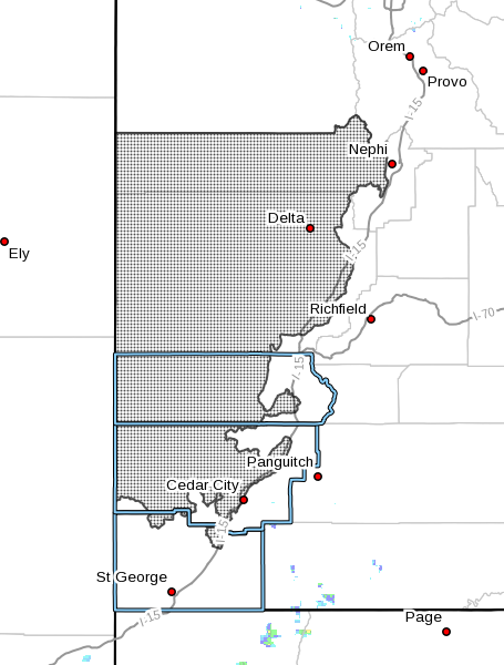
ST. GEORGE — The National Weather Service has issued a high wind watch for parts of Washington, Iron, Beaver and Millard counties Sunday from noon until 10 p.m.
A storm system currently over the eastern Pacific is forecast to track east across the great basin. A strong cold front associated with this storm will advance east across Nevada Sunday generating increasingly strong south winds Sunday afternoon through early evening. The front will cross Utah Sunday night with a short period of strong northwest winds trailing the front across northwest Utah.
South winds of 20-30 mph are forecast to occur Sunday morning increasing to between 30-40 mph with gusts approaching 60 mph by late Sunday afternoon or early evening.
Affected areas
The high wind watch will affect west central and southwest Utah, including the cities of Delta, Fillmore, Beaver, Cedar City and Milford.
Timing
South winds will develop late tonight then increase throughout Sunday morning. The strongest south winds will develop by late in the afternoon and remain strong until the cold front moves through the area late Sunday evening.
Impacts
Strong crosswinds will make for hazardous travel conditions along all west to east roadways. Blowing dust could produce areas of very low visibilities. Wind sensitive operations will be impacted.
Precautions
Sustained wind speeds of at least 40 mph or gusts of 58 mph or stronger may occur. Motorists should be prepared for sudden gusty crosswinds which can make driving difficult.
Email: [email protected]
Twitter: @STGnews
Copyright St. George News, SaintGeorgeUtah.com LLC, 2016, all rights reserved.