UTAH – The National Weather Service has issued a hazardous weather outlook for the western two-thirds of Utah and southwest Wyoming in light of an incoming active weather pattern. The outlook sees rain and snow over the next seven days but less so in Southern Utah, which may have precipitation in the central mountains but generally dry conditions and December norms throughout the rest of the southern region.
Thursday
Snow will develop by Thursday afternoon then gradually turn to rain in the lower valleys as warmer air moves into the region from the west. Rising snow levels overnight will turn most precipitation to rain or a rain-and-snow mix in the valleys with heavier snow at times in the northern and central mountains.
Friday through Wednesday
A prolonged period of rain will exist across the northern half of the outlook area from Friday through Sunday evening.
Significant snow accumulations are anticipated for the northern mountains, with the greatest accumulations being in the northern Wasatch range. Valley locations will bounce between rain and snow through Saturday afternoon then turn primarily to snow late in the weekend.
The southern half of Utah will receive significantly less precipitation, with most of that confined to the central mountains. Temperatures are expected to remain at or above seasonal norms through the weekend.
Heading into early next week, colder air along with some additional snow will sag south into the northern half of the outlook area.
Down south, generally dry conditions are expected with temperatures running close to mid-December normals.
Current road conditions
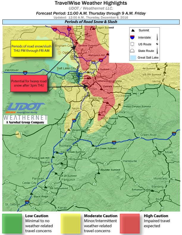
Utah Department of Transportation’s forecast largely echoes the Weather Service outlook, with its own road weather alert. UDOT anticipates snow developing over central and northern routes after 11 a.m. Thursday, becoming more heavy after 3 p.m. Particular to northern Utah, the alert states:
At least minor to moderate road snow/slush accumulations expected along the Wasatch Front from Utah Valley northward, with the notable exception being Salt Lake/Tooele Valleys. Heaviest road snow along valley/bench routes looks to occur north and west of Tremonton; Ogden eastward through Huntsville; and Provo Canyon to Heber. Significant road snow is expected across many summits and canyon across northern Utah. Portions of I-80 from Parleys Canyon to the Wyoming line will have impaired travel as well, with periods of moderate to heavy road snow as early as the Thursday PM commute.
Motorists are advised to take caution. Roadside snow is visible at the Scipio Summit on Interstate 15, with UDOT forecasting snow on the interstate north to Brigham City as well as on other routes to the north.
Email: [email protected]
Twitter: @STGnews
Copyright St. George News, SaintGeorgeUtah.com LLC, 2016, all rights reserved.
Well just be careful out there folks. Slow down and be safe and give yourself extra time to get to your destination. and enjoy the festive seasonal celebrations. Praise the Lord !
Doesn’t sound like we’re in for much of anything, that’s why I live here. On the other hand, think back to the snow we got three years ago almost to the day…I couldn’t leave the house for a week.