ST. GEORGE — Many in Southern Utah awoke to considerably cooler temperatures than they are used to for this time of year. Ushering in a cold front, these temperatures and accompanying winds are parts of both an advisory and outlook issued by the National Weather Service in Salt Lake City. A red flag warning issued over the weekend is also still in effect.
Wind advisory
Continuing a pattern that started at the end of last week, the National Weather Service issued a wind advisory in effect from 9 a.m. to 10 p.m. Monday.
Impacts
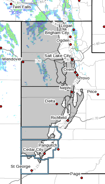
Affected areas include the west central and southwest valleys of Utah, the Sanpete and Sevier valleys, the Great Salt Lake Desert and mountains, the Salt Lake and Tooele valleys and the southern Wasatch Front.
St. George is not included in this advisory.
The advisory forecasts southerly winds 20-30 mph with gusts approaching 50 mph. Winds early this morning will increase behind the cold front sweeping east through the area and will remain strong and gusty through early this evening, then gradually taper off through late evening.
Significant travel impacts are anticipated, especially along west-to-east routes through western Utah from around Cedar City north to Interstate 80 in northwest Utah. Blowing dusts will also create areas of reduced visibility this afternoon through early this evening.
Red flag warning
Despite cooler temperatures, humidity is still low, and with high winds forecast for Monday, the National Weather Service still has a red flag warning active in portions of west-central and Southern Utah through Monday evening, including the northwestern two-thirds of Iron County and the majority of Kane and Washington counties.
Relative humidity is not forecast to go above 17 percent.
Residents are reminded to maintain vigilance with being fire smart, as human-caused fires are already being reported, including two in the Dixie National Forest.
Read more: Human attention means fire prevention: Tips to stop human-caused fires
Additionally, residents are reminded not to operate drones or any unmanned aircraft in areas where wildland fire fighting is ongoing.
Drones create a potential safety hazard for those involved in airborne fire suppression operations and can result in fire managers temporarily suspending aerial firefighting operations or worse – damage or destruction of firefighting aircraft, injury or death of personnel involved in firefighting efforts. Utah law allows a range of fines up to $15,000 and terms of imprisonment for convicted offenders.
Read the law: Utah Code Section 65A-3-2.5 regarding wildland fire and unmanned aircraft
Hazardous weather outlook
The National Weather Service also issued a hazardous weather outlook for the western two-thirds of Utah and southwest Wyoming starting Monday through the next seven days.
Day one – Monday
A strong cold front will sweep east across the outlook area Monday. Strong southerly winds ahead of the front will continue out of the west to southwest behind the front Monday afternoon through the evening. The strongest winds will exist across the southern two-thirds of Utah late-morning through around mid-evening.
Significantly colder temperatures will follow the cold front. High temperatures Monday could run as much as 15 to 25 degrees colder than Sunday’s highs, with the coldest temperatures across the northern and western portions of the outlook area.
While the southern portions of Utah will only see winds and cooler temperatures, showers along with a few thunderstorms will develop across northern and western Utah Monday. These showers and storms will shift into northern Utah and southwest Wyoming.
High elevation snowmelt will continue to cause swift, high and very cold flows along the waterways of northern Utah and southwest Wyoming. Avoid areas adjacent to waterways that are fed by high elevation snowmelt. These fast and cold waterways are deadly, as a person or pet can drown in less than a minute if they fall in.
Days two through seven – Tuesday through Sunday
For those traveling north this week, widespread valley rain and high elevation snow will exist across the northern third of Utah and southwest Wyoming early Tuesday. Accumulating snows are possible at the higher elevations of the Wasatch and western Uinta mountain ranges. These accumulations are expected to be minor and will have little or no impact on travel during the day.
A mild westerly flow aloft will develop by Wednesday, and remain over the region through the upcoming weekend. Temperatures should return to seasonal norms on Wednesday, then continue to warm up across southern and central Utah through Sunday.
Higher temperatures will bring increased runoff, and waterways will see increasing flows. Children and pets should be kept away from these fast flowing, cold waterways.
Email: [email protected]
Twitter: @STGnews
Copyright St. George News, SaintGeorgeUtah.com LLC, 2017, all rights reserved.