More storms expected throughout Southern Utah Saturday – Bookmark this page for continuous updates
- Update 7:35 p.m. Flash flood warning issued for central Kane County.
- Update 7:15 p.m. Latest flash flooding information for southeastern Iron County.
- Update 5:55 p.m. Flash flooding still imminent following 2 inches of rain fall.
ST. GEORGE — The National Weather Service in Salt Lake City has issued flash flood warnings Saturday affecting central Kane County and areas near the Brian Head burn scar.

Central Kane County
At 7:22 p.m. MDT, Doppler radar indicated thunderstorms producing heavy rain over the Paria, Coyote and Wahweap drainages. Up to one inch of rain has already fallen, and additional rainfall will fall on the aforementioned basins.
This flash flood warning is in effect for central Kane County until 12:30 a.m. MDT Sunday.
The town of Big Water is likely to experience flash flooding.
Southeastern Iron County
At 6:15 p.m. MDT, Doppler radar indicated a thunderstorm producing heavy rain over the western Brian Head burn scar, specifically the Parowan Creek drainage. Up to one inch of rain has already fallen.
This flash flood warning is in effect for Southeastern Iron County until 9:15 p.m. MDT.
Western Garfield County and east central Iron County

At 3:11 p.m. MDT, Doppler radar indicated a thunderstorm producing heavy rain over the Brian Head burn scar, specifically the Panguitch and Clear Creek drainages. Up to one inch of rain has already fallen. Flash flooding is expected to begin shortly. The warning is in effect until 6:15 p.m. MDT for western Garfield County and east central Iron County.
As of 4:38 p.m. MDT, heavy precipitation has come to an end over the warned area however flash flooding may still be occurring due to the 2 inches of precipitation which fell over the previous 2 hours.
Flash flooding will remain over mainly rural areas of western Garfield and east central Iron Counties. Excessive rainfall over the Brian Head burn scar will result in debris flow moving through the Panguitch/Clear Creek drainages, including SR-143. The debris flow can consist of rock, mud, vegetation and other loose materials.
Read more: This is how monsoons could menace communities around the Brian Head burn scar
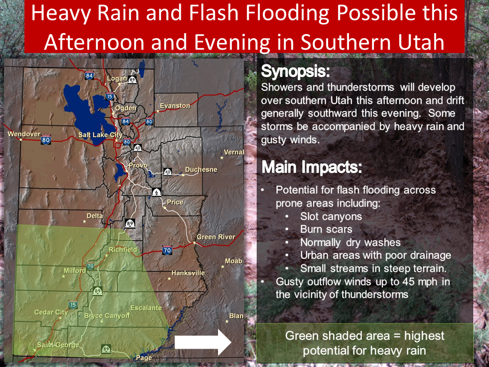
Rains continue Saturday
Showers and thunderstorms will develop over Southern Utah in the afternoon and evening. Heavy rains and wind gusts of up to 45 mph may accompany these storms.
Impacts
Areas most prone to flash flooding include:
- Slot canyons.
- Burn scars.
- Normally dry washes.
- Urban areas with poor drainage.
- Small streams in steep terrain.
Flash flood precautions
If a debris flow has occurred, it is important to realize that the runout area remains very dangerous. Additional debris flows may occur within minutes of the original flow. Please remain vigilant and be prepared to take swift action.
“Turn around, don’t drown” when encountering flooded roads. Most flood deaths occur in vehicles.
Remain alert for flooding even in locations not receiving rain. Dry washes, streams and rivers can become flooded with raging killer currents in a matter of minutes, even from distant rainfall.
People in the warning area are advised to move to higher ground immediately. Residents living along streams and creeks should take immediate precautions to protect life and property.
Email: [email protected]
Twitter: @STGnews
Copyright St. George News, SaintGeorgeUtah.com LLC, 2017, all rights reserved.