FEATURE — There has been a bit of a debate over the years as to how La Verkin got its name. The Daughters of Utah Pioneers monument in town erected in 1949 states that La Verkin is “Indian for Beautiful Valley.”

However, many conclude that is more likely a corruption of the Spanish “La Virgen.” Another theory is that it could possibly be an error in the transcription of the term “beaver skin.” For instance, pioneer leader John D. Lee called La Verkin Creek the “Levearskin river” in a diary entry in 1852.
There is also a debate as to whether there is a space between the “La” and “Verkin” with it spelled each way in documentation and even signs on the landscape. Most locals will tell you that the correct way to spell the name is with the space in between. That is how it appears on the town’s welcome signs.
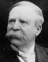
Whatever the debate over the name, the city owes its establishment to the same man who established the longest-running, continuously operated business in the county — enterprising pioneer Thomas Judd. Once only a place where Toquerville residents’ cattle grazed, Judd saw potential in what was then called the La Verkin Bench.
“He became interested in the fertile soil, and dreamed of this bench becoming ‘the garden spot of Dixie,’” Maude M. Judd, Thomas Judd’s daughter-in-law, recorded in her volume,“History of La Verkin.”
Judd envisioned the construction of a canal that could bring water to the bench. Civil engineer Isaac MacFarlane completed an initial survey for a canal in November 1888 and Judd and business partner Thomas Cottam used that survey to help determine the length of the canal and the probable cost, Andrew Karl Larson wrote in his book “I Was Called to Dixie.”
Thomas Judd became the president of the La Verkin Fruit and Nursery Company when it was incorporated in June 1889.
“The object of the company was to establish nursery orchards and vineyards, to manufacture wine and liquor, to promote fruit raising, stock raising, and general farming,” Laura Hardy wrote in her essay about the La Verkin Canal’s history.
The canal commenced with a long tunnel first. Hardy wrote that the workers used a row of lighted candles to aid in keeping a straight line.
“When the two crews met at the center, they found that Mr. Macfarlane was only six inches off in his calculations,” Hardy wrote. “The tunnel was 840 feet in length.”
Much of the canal work involved blasting with black powder and some parts had to be built on supporting rock walls and fills, Larson noted. It was hard work, completed without power tools on steep ledges and talus slides. On average, the canal was five feet wide on the bottom, seven feet wide on top, and two feet deep.
La Verkin Canal workers received an average of $1.50 per day for their labor. The wage was not paid in cash, however. Judd paid half the wage in Washington Cotton Mill Factory scrip, which at the time Judd was leasing. During his tenure it was as much of a store as it was a factory. Workers could redeem Cotton Mill scrip at full face value at the actual mill or could spend it in town at a discounted amount. The other half of the wage came in La Verkin Fruit and Nursery Company stock.
“Some of the La Verkin Bench was given as stock,” Hardy wrote. “It had an appraised value of $25 to $35 per acre.”
When completed, several accounts describe how proud the workers and canal company stockholders were of their work and that the canal looked flawless. However, keeping water in it, at times, proved to be a challenge as soon as the water started flowing through the canal in April 1891.
The water caused the miniature cracks already present to widen. Workers first tried “bentonite clay” to fill the canal to no avail. They even tried lint from the Cotton Mill, roughage leftover from making sorghum molasses as well as straw, but had little success.
As the canal was being finished, the company planted almond trees, fruit trees and grape vines. That first summer, in order to save those orchards and vineyards, a crew of men was hired to work on the canal night and day, Maude M. Judd recounted.
Many became discouraged with the project upon seeing this, but Thomas Judd mortgaged his home in St. George to have flumes built to carry the water over the worst places, Maude M. Judd wrote in her history.

“For four years the trouble persisted,” Hardy noted. “Only 160 acres of the bench was brought under cultivation, and that small quantity of land constantly suffered from want of water.”
By 1897, the trouble of keeping water in the canal was so difficult, it threatened to bankrupt the company, which had to sell some of its stock to meet its expenses. It wasn’t until about 1910, when Judd found out some St. George farmers had been successful in lining their canals with cement. He decided to buy some bags of cement and see if it would work for the La Verkin Canal. The experiment with cement was a success and “greatly relieved their troubles,” Hardy wrote.
The selling of the stock in 1897 led to the balance of the company’s property being divided among the stockholders in proportion to the stock held by each. From this time forward the people began to work their individual land, Cherrie Gubler Naegle wrote in her book “La Verkin: The Town Of My Youth.”
In 1898, a townsite was surveyed. That same year, Thomas Judd was called to take charge of the White River colonization for The Church of Jesus Christ of Latter-day Saints. Judd needed someone to take care of his farm who wasn’t afraid of hard work.
He chose brothers Joseph and Henry Gubler, of St. George, and their brother-in-law, James Pectol. The three men and their families agreed to move to La Verkin and became the city’s first permanent residents. Once their time taking care of Judd’s farm was up, Joseph and Mary Gubler and Henry and Susanna Gubler bought land of their own and decided to make La Verkin their home. The Pectols moved back to St. George.
Many of the early residents first built adobe homes and later constructed larger lumber homes to settle into. Many of these permanent homes include boweries or arbors for much-needed shade and extended living space. A large number of the incoming settlers after the initial three families were related to those already living in La Verkin.
Even after they started using cement to fix the canal, there were still regular problems with it. Old timer and former “Spectrum” correspondent Richard Howard, tells the following story:
“Loren Squire, one of the ditch masters and president of the LaVerkin Canal Company, told me of how he’d let a small stream of ditch water ‘trickle’ outside his bedroom window and, if in the night suddenly the ‘trickle-sound’ would stop, he’d know there was a break in the canal somewhere. It was imperative to get that hole fixed as the longer it ran the more of the canal would be washed away – a huge project to repair. The ditch and irrigation water were as common a theme of conversation as the weather.”

La Verkin’s early development
In 1902, the company became known as the La Verkin Bench Canal Company. In a 1903 meeting of stockholders, the company moved to establish public infrastructure for a town, including a post office, cemetery and school district. Henry and Susanna Gubler’s home became the first post office.
The first Sunday School class took place in a bowery built near where the first church and schoolhouse would be built in 1904. The first LDS ward was organized in June 1904 and the church/schoolhouse was finished in December 1904, a proud achievement for the fledgling town.
Even though he never lived in La Verkin, Thomas Judd took a keen interest in its residents and “did all he could to help those in need, accepting labor, ditch pay, produce, or anything they had to help them in paying for their land” and it was not uncommon to see many of these men sitting down at the table of his plural wife, Mary Jane (who did live in La Verkin) to enjoy a good meal, Maude wrote in her account.
True to Judd’s vision, La Verkin proved an excellent place to raise fruit and nuts. Harvesting fruit was almost a rite of passage for La Verkin youth in the early days. A few early residents engaged in turkey farming and E.J. Graff, who operated Graff Mercantile in Hurricane, also operated a large chicken farm. Another staple crop early on was sorghum, which, according to Victor Hall in his “History of La Verkin,” “was probably LaVerkin’s single most important ‘money’ crop.” Since sugar was prohibitively expensive at the time, sorghum molasses became the sweetener of choice.
“There were as many as seven sorghum mills in operation at one time,” Hall noted. “Every fall La Verkin farmers headed north to peddle sorghum molasses. Sometimes they received cash,
Sometimes they traded for potatoes or flour. The term ‘sorghum lappers’ was bestowed on Dixie residents by crass individuals who lived in Iron County and points north.”
Another boon to the residents of La Verkin was the construction of the one-lane Hurricane/La Verkin Bridge in 1908, a rigid Warren pony truss type bridge, which is still standing. Prior to the bridge’s construction, traveling between the two communities required crossing the streambed of La Verkin Creek as well as the sometimes treacherous Virgin River.
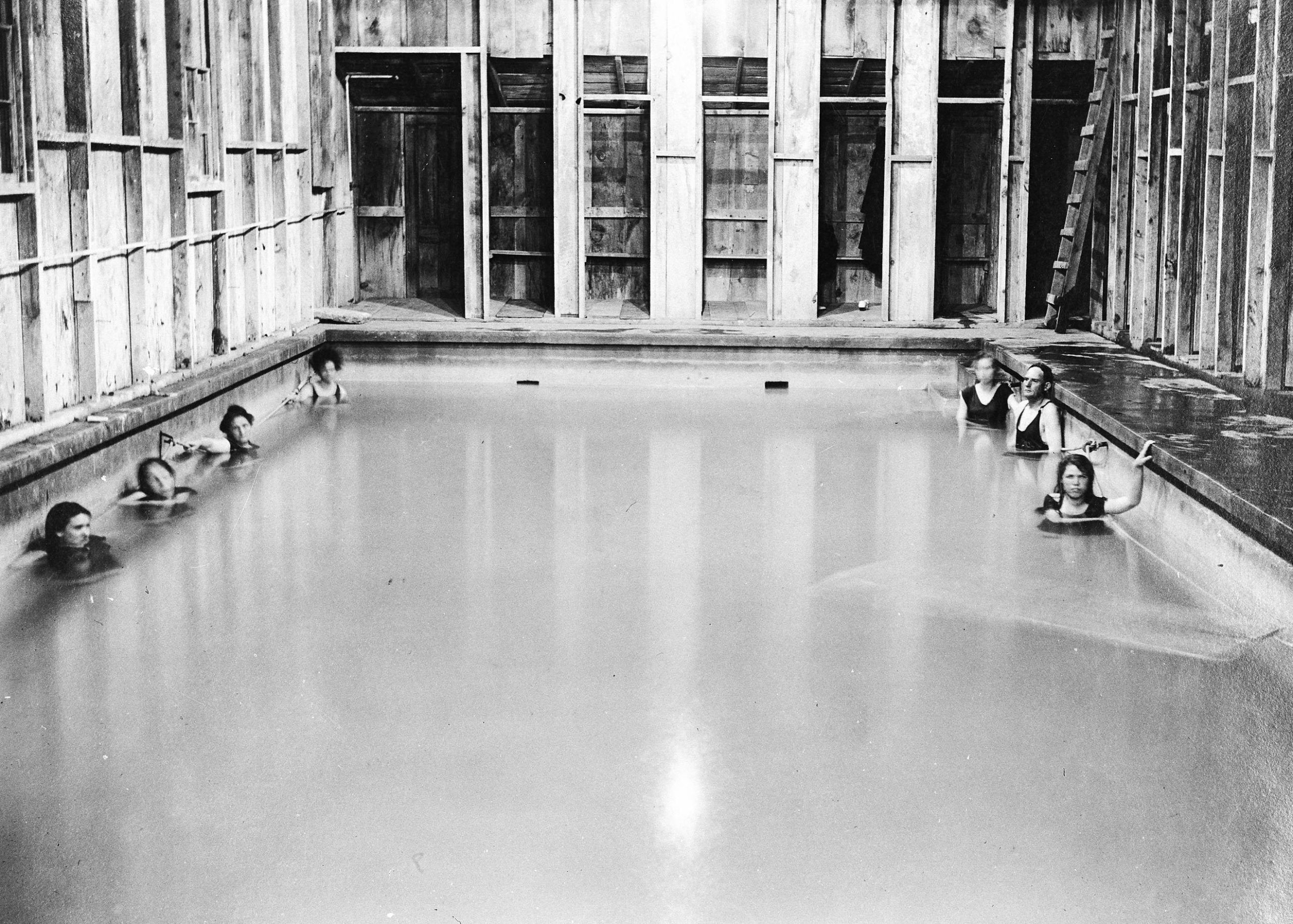
In 1915, the La Verkin Sanatorium and Resort Company formed to develop the hot springs on the banks of the Virgin River near the town as a resort after purchasing the springs and 170 surrounding acres from Thomas Judd. The original cement swimming pool opened in 1918. Known as “Pah Tempe,” it became a favorite recreation spot and many children in La Verkin and Hurricane’s early days were baptized in its pools. It changed ownership several times before closing in 2013.
Between 1925-1926, a new church was built in sections. It was truly a multipurpose building, serving as a chapel on Sunday, a drama theater or a dance hall on Friday or Saturday nights, and a gymnasium for basketball. It had seating for 600 people and when first being planned, the Church’s First Presidency felt that it was too large but the La Verkin Bishopric stood firm about the size. It took 30 years to pay for the building and it was not formally dedicated until January 16, 1955. In 1962, a new chapel was added on the south side. Today the building serves as the city’s police station.
In 1929, Dixie Power built a small hydroelectric plant on the north bank of the Virgin River in Confluence Park. The plant used water from a penstock built from the La Verkin Canal to power the Pelton wheel that generated the electricity. The plant was the largest of a network of four such power plants in the county.
Early on, the plant provided all the electricity La Verkin, Hurricane, Toquerville, Virgin, Rockville and Springdale needed. The plant’s caretaker would walk the length of the La Verkin Canal to make sure it was flowing properly much like the ditch riders of the Hurricane Canal did on the south side of the gorge. The plant operated until 1983. It is now owned by Washington County, who plans to restore it as an interpretive center.
During the winter of 1933-1934, La Verkin was home to a Civilian Conservation Corps camp which hosted young men from across the country working on erosion control. The camp was located just north of Highway 9 around 100 East.
Until 1937, La Verkin residents had to travel to St. George via Toquerville and Anderson Junction on old Highway 91, but that all changed that year when an oiled highway with a two-lane bridge was built. The new bridge rose 400 feet above the river, meaning vehicles did not have to descend to the river’s level to cross it on the old one-lane bridge anymore. Two of the main challenges of the bridge’s construction were the sometimes incessant wind as well as the builders keeping a cool head while working in such high places, Howard wrote in a 1975 “Spectrum” article about the bridge.

“I loved that high work,” Luther Fuller, one of the bridge’s foremen said, as quoted in Howard’s article. “It’s thrilling, giving a sense of accomplishment working up there. When that wind came up, I wasn’t worried. The engineer next to me started hollering and yelling that we were going to go down, but I knew we’d be OK.”
Howard noted in his story that it was surprising there were no deaths in the bridge’s construction because “safety factors were nil.”
The bridge significantly cut the time needed to drive to St. George. In 2003, the bridge was expanded to four lanes, two lanes in either direction.
To many, growing up in La Verkin was an idyllic experience.
“Life as a youth in La Verkin was as near perfect as anywhere one could grow-up,” Howard noted. “The hot springs, irrigation water, and the canal were key factors in my youth.”
Howard grew up on a large farm where he still lives.
“I remember some of the old timers relating how they’d fill their cisterns with ditch water to ‘let it settle’ so they could use it for their household needs,” he recounted. “When the ‘ditch would go out,’ we’d be days or weeks without water and a real fear of our crops and trees dying in the hot summer sun.”
According to many, La Verkin was a very social place.
For instance, the town held July 24th celebrations as well as Christmas Eve programs in the recreation hall of the old church. The ward would also get together every October for a gathering in back of the church. Children loved to play in the river or the canal. Families would play games together after church.
Talking to old timers and reading accounts in Naegle’s book, La Verkin is a place of fond memories for those who grew up there.
Visiting La Verkin Today
Sitting at the highway turnoff where most of Zion National Park’s approximately five million annual visitors pass through on their way to see its monoliths and narrow canyons, La Verkin isn’t that small, idyllic town anymore.
Signage welcoming motorists to the city call it “The Bridge to Zion” and a cement sculpture at the Highway 9 turnoff towards the national park depicts Zion’s monoliths, labeling La Verkin as the “Zion Canyon Corridor.”
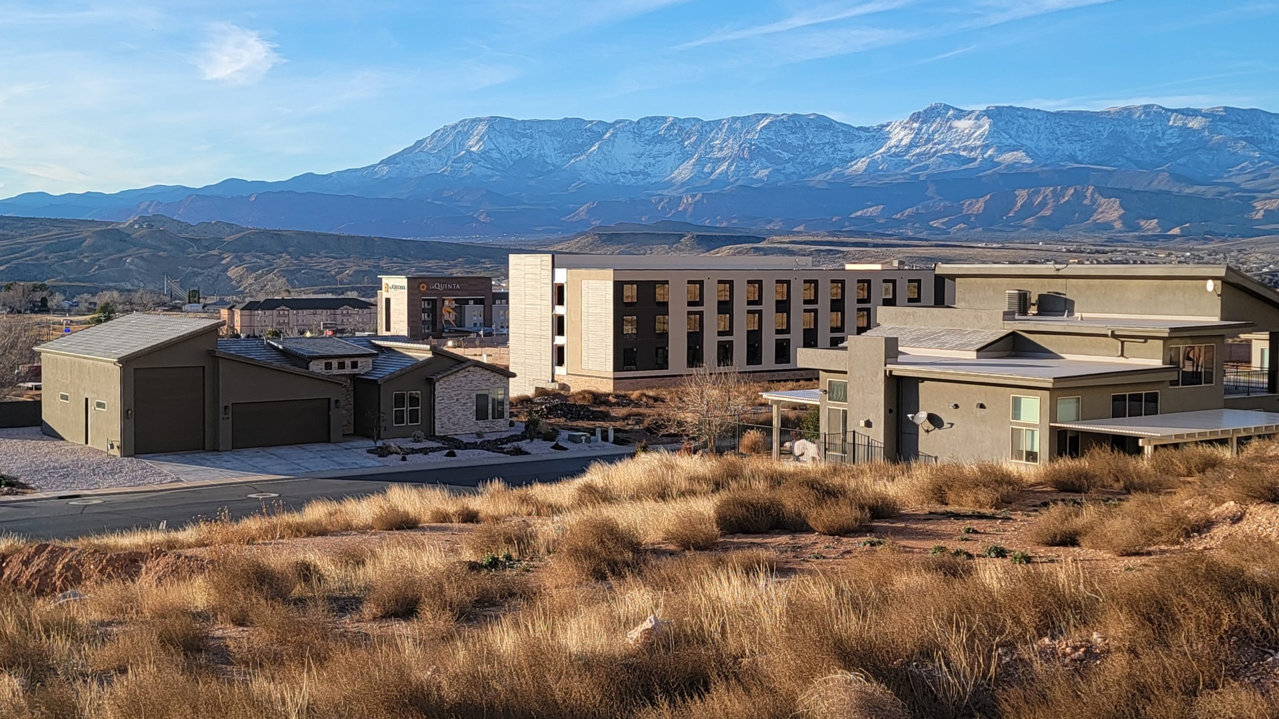
Most of the old orchards that were the reason for the town’s settlement have now been “planted” to houses. Tourism is central to the city’s economy and growth has been significant in the last decade with the addition of new hotels and restaurants.
“The growth is taking us from a small farm community tied to a common theme and into a future of small and large businesses and a tourist trade unknown to our early settlers,” Howard said. “So the challenge will be in the keeping of shared values and remembering, and respecting, the heritage given to us by the early settlers of this town and the water lifeline that tied us all together.”
Today’s La Verkin prides itself on being a business-friendly community, its current mayor, Kelly Wilson said in his welcome message on the city website.
“La Verkin City staff, planning commission and city council are working toward diversifying business types so that it is not only tourism,” councilwoman Patricia Wise explained. “That is not an easy task.”

Wise said after completing a transportation study with the Utah Department of Transportation, the city is looking at a new study to possibly develop a downtown area.
“There is strong interest from developers to start projects on the ‘top side’ – the east bench heading toward Zion National Park,” Wise said. “But, first we need to manage our water availability, use and promote conservation.”
The city is hoping to develop more recreation opportunities within the city, such as working toward restoring the canal for a regional hiking/biking trail in the future. As noted before, Washington County is looking into restoring the old power plant as an interpretive center. The new Power Plant Park provides a wonderful view of the plant and Confluence Park as well as interpretive plaques about the former power plant’s history.
Confluence Park, the Virgin River bottomlands between La Verkin and Hurricane, is a wonderful place for recreation and includes historical sites such as the old power plant, a former turkey granary and a former dairy farm. Access points into Confluence Park in La Verkin are from the Power Plant Park, the far west end of Center Street and the terminus of the road through the Riverwoods Development on the north end of town.
For more information on La Verkin, check out the city website.
Photo Gallery
This photo shows some of what is left of the La Verkin Canal, as seen from the south side of the gorge above the old Hurricane Canal, Aug. 14, 2021 | Photo by Reuben Wadsworth, St. George News The first home of Henry and Susanna Gubler, some of La Verkin's first settlers, still stands near the home they built and moved into in 1915, date unspecified | Photo courtesy of Cori Gubler, St. George News This bungalow, built by Henry and Susanna Gubler in 1915, has been restored, date unspecified | Photo courtesy of Cori Gubler, St. George News This bungalow, built by Henry and Susanna Gubler in 1915, has been restored, date unspecified | Photo courtesy of Cori Gubler, St. George News This historic photo shows the inside pool at the La Verkin/Pah Tempe Hot Springs, date unspecified | Photo courtesy of the Washington County Historical Society, St. George News This historic photo shows the two bridges that connect La Verkin and Hurricane, date unspecified | Photo courtesy of the Washington County Historical Society, St. George News This recent photo shows the former Pah Tempe Hot Springs as well as the two bridges that connect Hurricane and La Verkin, Jan. 13, 2024 | Photo by Reuben Wadsworth, St. George News This historic photo shows an aerial view of La Verkin with the old white church at the bottom of the picture, circa 1950s | Photo courtesy of the Washington County Historical Society, St. George News A plaque recounting a brief history of the La Verkin Canal stands along the Hurricane Canal, Aug. 21, 2021 | Photo by Reuben Wadsworth, St. George News Once an important gathering place for the La Verkin community, the old white church is now the city's police headquarters, June 21, 2019 | Photo courtesy of Kyle Gubler, St. George News Once an important gathering place for the La Verkin community, the old white church is now the city's police headquarters, Jan. 26, 2024 | Photo by Reuben Wadsworth, St. George News Washington County now owns the old La Verkin hydroelectric plant and plans to restore it as an interpretive center, May 31, 2015 | Photo courtesy of Kyle Gubler, St. George News Confluence Park includes a nearly-intact former granary for a turkey farm as well as a new bridge for hikers to cross the river along the trail that connects the La Verkin side to the Hurricane side, Oct. 20, 2022 | Photo by Reuben Wadsworth, St. George News This photo shows a view of La Verkin in the fall, 2009 | Photo courtesy of Kyle Gubler, St. George News The La Verkin baseball field near the elementary school bears the emblem of the city's Winterfest, held the first weekend of December, Jan. 26, 2024 | Photo by Reuben Wadsworth, St. George News The "topside" of La Verkin has experienced major development in the last decade with hotels, subdivisions and an RV resort, Jan. 26, 2024 | Photo by Reuben Wadsworth, St. George News


About the series “Days”
“Days” is a series of stories about people and places, industry and history in and surrounding the region of southwestern Utah.
“I write stories to help residents of southwestern Utah enjoy the region’s history as much as its scenery,” St. George News contributor Reuben Wadsworth said.
To keep up on Wadsworth’s adventures, “like” his author Facebook page.
Wadsworth has also released a book compilation of many of the historical features written about Washington County as well as a second volume containing stories about other places in Southern Utah, Northern Arizona and Southern Nevada.
Copyright St. George News, SaintGeorgeUtah.com LLC, 2024, all rights reserved.